
BACKGROUND
For communities with few alternative routes, a highway closure can mean a long detour or loss of road access. When a storm or wildfire affects several roads at once, closures can interact: a route that provides a way around one disruption may itself become unavailable. The consequences depend on the wider network and the communities it connects.
Road information services such as DriveBC.ca describe current conditions and closures across the network. Planning for a storm or wildfire also calls for the ability to anticipate how conditions might develop and compare possible responses before acting. That could mean projecting which routes a spreading fire might reach or testing whether additional plows could keep a pass open.
Digital twins support these predictive and what-if capabilities by combining observations of a physical system with models of how it behaves. Manufacturers use them to anticipate equipment failures, while water utilities use them to investigate problems in their networks. Transportation also has established simulation tools such as SUMO (Simulation of Urban MObility), which models individual vehicles and junctions to explore changes in urban traffic flow.
At the scale of a highway network, the challenge is how these models work together. Physical relationships can describe snow building up on a road or a fire spreading, but they do not by themselves explain the consequences for access across a province. Those consequences depend on local conditions interacting with maintenance decisions and the connections between roads. The question is whether linking these different models can produce a useful understanding of the system as a whole.
HYPOTHESIS
We hypothesized that combining local models of road conditions with a connected highway network would reveal risks to community access that are difficult to identify from individual road reports. The twin should show how disruptions interact and allow people to compare the consequences of different operational responses before acting.
With sufficient weather and maintenance inputs, it should also identify routes at risk of becoming unavailable as conditions develop. This would extend the value of the network model from understanding current disruptions to anticipating potential ones.
APPROACH
Understanding access across the network
The first requirement was a representation of how roads connect. We represented the highway network as a graph, with junctions and road endpoints joined by links representing the roads between them. When a closure removes a link, the remaining connections show whether a journey is still possible. Travel directions and ferry links matter because a connection on a map is only useful if it can actually be travelled.
The prototype uses OpenStreetMap for this connected network, matched to BC’s Digital Road Atlas highway identifiers. Its coverage also extends into Alberta and the Yukon, because an alternative route may leave BC and return. This network supports questions about community access and detour distance. Without traffic-volume data, it cannot say how much congestion a detour would create.
Road availability changes over time, so observations need to update the graph. A common data interface allows each reading to identify its source, time and location, which the twin matches to the network. Keeping the sources separate from the twin means a simulated feed can later be replaced by a live integration. BC already has feed definitions for DriveBC.ca road events through Open511 and the wildfire list, with incoming data retained for replay and outages recorded.
Exploring decisions before conditions change
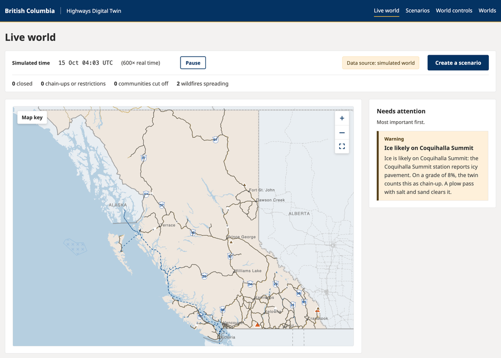
A connected network can explain the consequences of a reported closure. Looking ahead also requires models of how conditions develop. Snow accumulation and maintenance capacity, for example, provide a way to explore whether available plows could keep up with a storm. Road surface and closure models translate those estimates into possible restrictions, while a wildfire model projects which roads and communities a fire might approach.
These are deliberately simple models. They make it possible to explore how estimates could support decisions within the twin, but their assumptions would need specialist calibration before operational use. The fire model omits terrain, firebreaks and windblown embers, and currently represents conifer forest rather than a full range of fuel types.
The scenario feature brings the network and condition models together. Users can change road availability, weather or maintenance resources in an independent scenario and examine the consequences without altering the live model. This supports comparisons between possible responses as well as possible disruptions. The useful question becomes how a decision changes access or conditions over time, rather than simply whether an event can be displayed.
In the prototype, scenarios branch from the simulated world’s state. With real operational feeds, the intended starting point would be the twin’s current state. Separating provincial settings from the shared system also allowed an Alberta twin to run alongside BC, providing a practical test of whether the architecture could be reused.
Checking the answers when live data is unavailable
Simulation served both as a source of unavailable inputs and as a way to evaluate the answers. A 120-day simulated winter covered 24 demonstration stretches, using DriveBC.ca’s 132 real station locations with simulated readings. A second environment replayed 45 days of summer weather and fire activity from Environment Canada and BC Wildfire Service records, with simulated fire growth and closures.
The twin received only the observations delivered through its feeds, while the simulator separately recorded the underlying conditions. Introducing delays, outages and incorrect readings let us examine whether the twin recognized uncertainty and how far its estimates departed from what was happening in that environment.
The wildfire tests included simulated fire perimeters, satellite hotspots and wind readings. Those inputs are richer than BC’s current live wildfire feed of fire locations, sizes and statuses. This distinction matters when considering what the prototype demonstrates and what further integrations an operational version would require.
RESULTS
The experiment demonstrated that a highway digital twin can connect local conditions to consequences across a wider network. It identified risks to community access, compared the effects of different maintenance resources and explored how a spreading hazard could affect roads. These capabilities supported the core hypothesis and showed practical potential for planning and operational decisions.
The tests used public network and community data with simulated closures and operational conditions. They demonstrated what the prototype could do under controlled conditions; predictive performance against real highway conditions remains to be established.
Connecting closures revealed risks and alternatives
A simulated landslide at Coquihalla Summit produced a 213 km detour via Highways 3 and 5A, adding 103 km without isolating a community. Testing all 276 pairs of the 24 demonstration stretches went further, identifying combinations that removed the alternatives themselves.
Two pairs isolated communities that remained connected when either road closed alone. Pine Pass and the Hart Highway at Bear Lake affected three communities, while Duffey Lake and Sea to Sky at Squamish affected five. This demonstrated how the twin could identify consequences that would be difficult to assess by considering each event separately.
The answers also reflected different travellers’ options. Closing Sutton Pass isolated five communities, while chain-up restrictions kept them reachable for equipped heavy trucks and cars with winter tires. At Pine Pass, heavy trucks without chains could still travel through Alberta, although the detour added 1,095 km.
Across the modelled network, 122 of 606 communities were vulnerable to a single-road closure. Recognizing routes through Alberta and the Yukon was important: their inclusion reduced the count from 167. The assessment covers communities in the map data and remains incomplete, with some First Nations communities missing, resource roads and US routes excluded, and seasonal ferries treated as year-round connections.
Scenarios made the consequences of maintenance choices visible
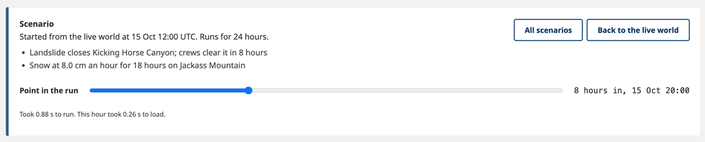
During a simulated heavy storm, all three tested Okanagan passes closed with one plow serving the region. Eight plows making more frequent rounds kept all three open. This connected a change in operational resources to its consequences for road access, demonstrating the scenario feature’s potential to support comparisons before resources are committed.
The twin could also track changing road status, although advance warnings were less dependable. The first closures occurred before a forecast arrived, and underestimated mountain snowfall led to a missed return to chain-up. There were false warnings as well. The comparison of maintenance options was therefore a stronger result than the prediction of precisely when restrictions would become necessary.
The twin responded to changing hazards and missing information
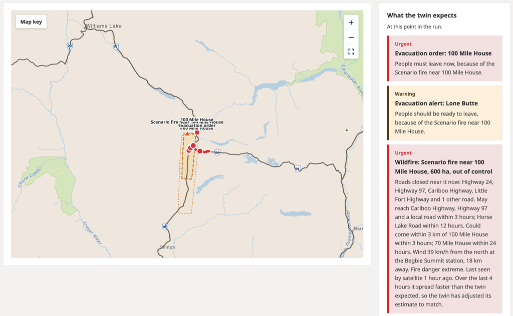
During the run that introduced a hypothetical fire near 100 Mile House, the twin anticipated five of seven fire-related road closures with one to two hours of warning. For Highway 97, two hours was the most warning possible: the fire reached the road three hours after starting, and the twin first received a report about an hour in. When the wind changed, its revised projections identified two roads that closed an hour later.
The test showed how new observations could change the assessment of road access as a hazard developed. It also produced five false alarms and missed two closures caused by distant fires without nearby wind readings. Because the twin and simulator shared fire-spread rules, these figures demonstrate responsiveness within the experiment rather than real-world wildfire forecasting accuracy.
Where observations were missing, the prototype could make that gap visible. Within its station-matching range, 69% of the network had no DriveBC.ca weather station, leaving 11 of the 24 demonstration stretches unknown throughout the winter tests. For stretches with stations, two hours of silence or unchanged readings caused conditions to be marked unknown. This made the limits of the available information part of the answer.
The same architecture supported another province
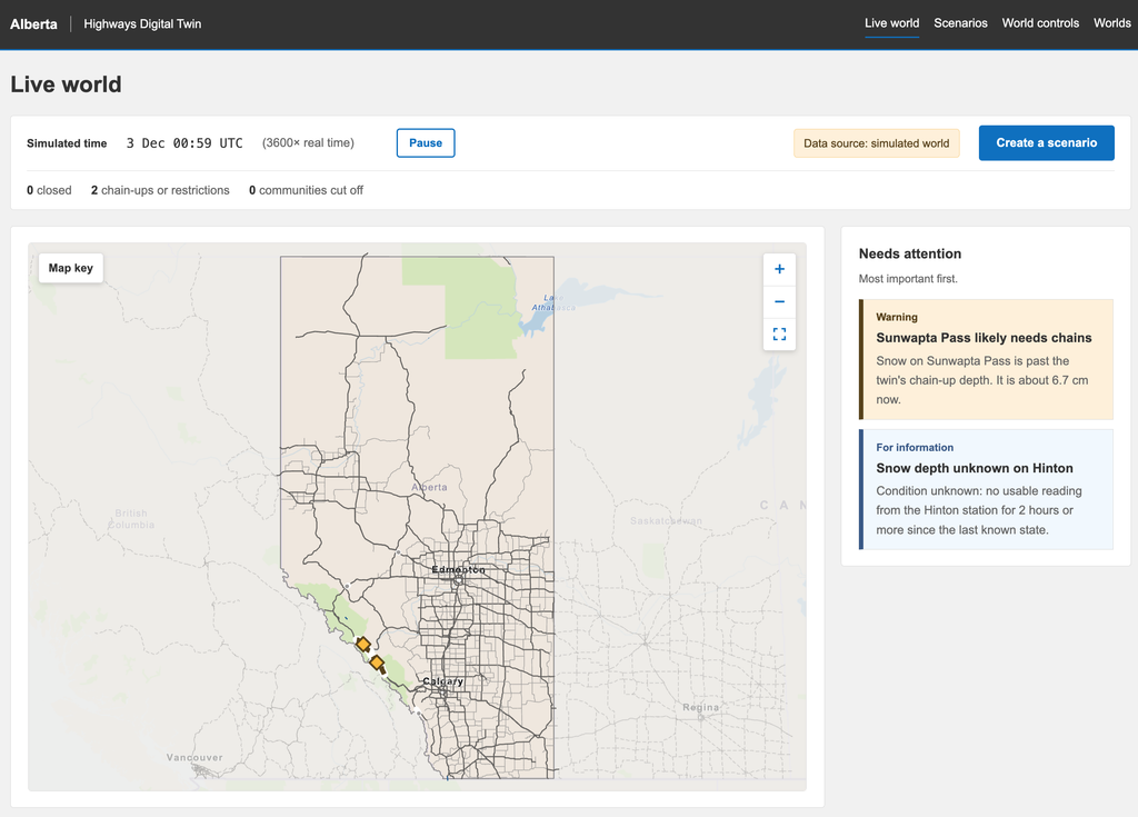
The Alberta twin worked without changes to the shared code, demonstrating that the network processing, models and screens could be reused. Its provincial configuration supplied a different network and neighbouring routes while keeping the underlying system intact.
The extension also clarified the work needed for operational use. Alberta currently uses simulated weather and stations, with no wildfire scenarios because provincial station and historical records have not been added. Local feed integrations and suitable model settings remain necessary, including fire modelling appropriate to grassland and aspen forest.
Development also refined how the twin interprets operational data, including frequent plow GPS updates and recovery after station outages. Together, these findings established a reusable prototype and identified the data and specialist modelling work needed to develop it further.
TAKEAWAYS
01
Connected events can reveal risks that individual reports do not. The paired-closure tests showed why modelling the network matters: either road could close without isolating a community, but losing both removed the alternative route. The distinction between closure and chain-up restrictions also changed who could reach a destination. These were the clearest demonstrations of value beyond reporting individual road events.
02
The network boundary is part of the answer. A useful access model needs to reflect the routes people can actually take, including those that cross jurisdictional boundaries. Its conclusions also depend on which communities are represented and when connections are available. These geographic and travel assumptions need checking as carefully as the condition models.
03
Available data determines how early the twin can warn. The twin could compare maintenance scenarios and respond to changing wind, but it could not anticipate conditions absent from its inputs. Forecast timing and station coverage directly limited the warnings it could give. An operational version would need suitable observations and forecasts as well as calibrated models.
04
Simulation made the limitations visible. Separating the simulated world from the twin’s observations let us find missed projections, false alarms and failures to recover from outages. The later plow tests showed that realistic message patterns matter too: frequent GPS updates were mistaken for repeated maintenance passes. Testing needs to reflect how operational data arrives as well as the conditions it describes.
05
Reusing the system still requires local data and expertise. The Alberta twin showed that the shared architecture could be reused without rewriting its models or screens. Each province still needs its own operational sources and settings suited to local conditions. The missing Alberta records and the fire model’s limited fuel types show where portability of the software outpaces readiness for operational use.
THE APP
Interested in seeing how the digital twin works? Contact us and we’d love to give you a demo.